Mexico · Coastal road trip
Beyond Cancún: Isla Holbox and the Flamingos of Río Lagartos
Two hours west of the Cancún hotel strip, the Yucatán's north coast turns to mangrove, sandbar and lagoon. A car-free island and a fishing town make an easy loop for anyone with three or four days.
At Chiquilá the road simply stops. A few taxi ranks, a guarded car park, a row of ticket booths and a concrete pier mark the end of the mainland, and beyond them a band of greenish water separates the coast from a low, flat line on the horizon. That line is Isla Holbox, and the boats that cross to it every half hour or so during the day are the reason the island still feels the way it does.
Holbox lies off the northern tip of the state of Quintana Roo, where the Caribbean coast turns west into the Gulf of Mexico. It is a thin sliver of sand, mangrove and lagoon, around forty kilometres long and in places barely a couple of kilometres wide. Since 1994 the island has been part of the Yum Balam flora and fauna protection area, which also covers the shallow Yalahau lagoon behind it and a slab of mainland forest. Getting there from Cancún takes two hours or a little more by road, and the change is far bigger than the distance suggests.
Plan your visit
- Duration
- Cancún, Chiquilá, Isla Holbox and Río Lagartos in three to four days at an easy pace More
- Getting there
- Ferry from Chiquilá, twenty minutes to half an hour; cars stay on the mainland More
- Getting around
- Walking, cycling or golf-cart taxis on Holbox; around three hours by road to Río Lagartos More
- Season
- Whale sharks gather from around mid-May to mid-September More
Across the lagoon to Isla Holbox
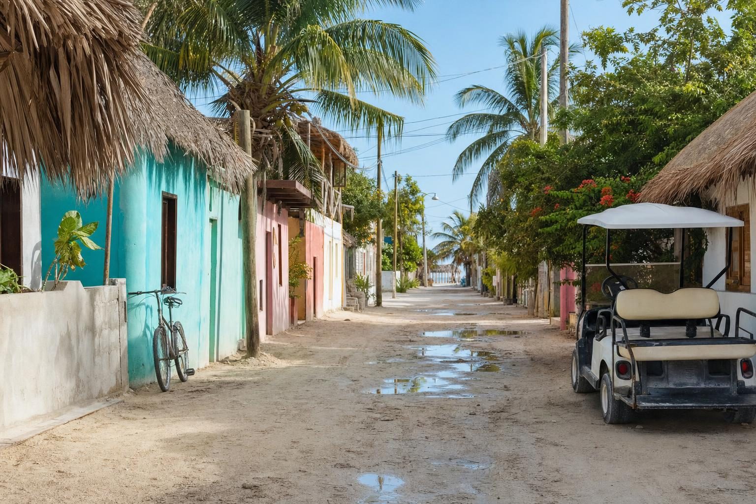
The ferry crossing is short, twenty minutes to half an hour depending on the boat and the wind. Pelicans sit on the posts of old fishing traps, and frigatebirds hang above the wake. Cars stay behind in Chiquilá. On Isla Holbox there are almost none: the streets are sand, and transport means walking, cycling or riding in the golf carts that wait at the pier as the island’s taxis.
The village spreads back from the ferry dock towards the north shore. Its houses are low, painted in pinks, turquoise and ochre, with many walls covered in large murals of fish, birds and faces. The main square has a church, a basketball court and food stalls in the evening, and the short walk to the beach passes restaurants, small hotels and the tour shops whose hand-painted signs advertise the island’s best-known attraction. The name Holbox is usually translated from Maya as black hole, a reference often linked to a dark freshwater spring nearby.
Beyond the village the island thins out. To the east, beach hotels are spaced along the shore, built low under thatch and palms. To the west, the sand runs towards Punta Cocos. In the opposite direction, past the last houses, sandbars stretch out at Punta Mosquito, where at low tide it is possible to wade a long way out through warm, knee-deep water towards flocks of wading birds.
Holbox is not a resort town, and much of its charm comes from that. The beaches can carry seaweed in some seasons, the streets turn to puddles after rain, and the mosquitoes at dusk are as committed as the island’s name for one of its points suggests.
The island’s street dogs
Every visitor to Holbox comes back with stories about the dogs. They lie in the shade of golf carts, follow strangers to the beach, sleep on restaurant steps and occasionally ride on scooters. Many belong to someone, and many more are quietly adopted by a shop, a bar or a hotel that feeds them and lets them sleep in the doorway. Local volunteers and visiting vets have run sterilisation campaigns on the island for years. The dogs have nothing to do with whale sharks or flamingos, yet they end up in almost every photograph.
Glowing water after dark
On dark nights in the warmer months, the shallows around Holbox can light up. The glow comes from bioluminescent plankton, microscopic organisms that give off flashes of blue-green light when the water is disturbed. Near the village the street lights wash it out, so guides take small groups by bicycle or kayak to quieter shores where the sky is black enough. Every step in the water leaves a trail of sparks, and a hand pulled through the shallows comes up dripping light.
It works best without a moon, and it cannot be booked like a show. Some nights the water is spectacular; on others there is only a faint shimmer.
Whale sharks in open water
The plankton matters for another reason. Each year, from around mid-May to mid-September, whale sharks gather in the warm, food-rich waters off the north-east corner of the Yucatán Peninsula to feed. The whale shark is the largest fish in the sea, a slow filter feeder with a checkerboard of white spots on a grey-blue back, and it is entirely harmless to swimmers.
Holbox whale shark trips leave early, in small boats that can spend an hour or more crossing open water before reaching the feeding grounds, which shift from season to season. The ride can be rough.
Once the boats find the animals, swimmers enter the water in turns with a guide, mask on, and try to keep pace beside a fish as long as a bus, which is almost impossible however hard anyone kicks.
The tours are regulated. Operators need permits, only a few swimmers are allowed in the water with each shark at a time, and touching is banned. Busy days still bring many boats to the same patch of sea, and the experience depends heavily on how carefully an operator follows the rules. If you book one thing in advance, make it a Holbox whale shark tour that limits its group size, briefs swimmers properly and keeps its distance; no other choice on the island matters as much. Many trips finish with a stop near the island to snorkel, watch for turtles or eat ceviche at anchor.
The road west to Río Lagartos
From Chiquilá, the drive to Río Lagartos runs inland through cattle country and small towns before turning north towards the coast at Tizimín. It takes around three hours, on two-lane roads with frequent speed bumps, known in Mexico as topes, which arrive with little warning. The north coast of Yucatán state is flatter and drier than the Caribbean side, and the villages are fishing ports rather than resorts.
Río Lagartos itself sits on the shore of a long, narrow coastal lagoon. The Spanish named it after the crocodiles they saw there, calling them lagartos, and the animals still live in the mangroves. The town is modest: a waterfront promenade, a few hotels and restaurants, fishing boats pulled up on the shore, and a steady trade in boat tours. Mornings start early, with fishermen heading out before dawn and herons waiting on the posts for scraps.
Río Lagartos flamingos at first light
The lagoon and its surroundings form the Ría Lagartos Biosphere Reserve, protected for its mangroves, dunes and seasonal wetlands. In 1986 the area became the first site in Mexico listed under the Ramsar Convention on wetlands of international importance, and UNESCO later recognised it as a biosphere reserve. Its most famous residents are American flamingos, which feed in the shallow, salty water and gather in large numbers to breed.
Boat tours leave from the town’s waterfront, ideally early in the morning when the light is soft and the water calm. Guides cruise out along the lagoon, slip through mangrove channels and cut the engine at a respectful distance from the flocks. The Río Lagartos flamingos are an intense pink, a colour that comes from carotenoid pigments in the small crustaceans and algae they eat. They feed with their heads upside down, sweeping their bills through the water, and when they take off they run across the surface first, legs pounding, before the whole group lifts away.
Seeing the Río Lagartos flamingos does not require a long day; most tours last two to three hours and are back in town before the heat builds. The same trips often pass crocodiles basking on the banks, pelicans, cormorants, spoonbills and ospreys. Some include a stop at a natural mud bath on the shore, where visitors smear themselves in pale clay before rinsing it off in the lagoon.
Pink water at Las Coloradas
A few kilometres east of Río Lagartos, the small settlement of Las Coloradas is built around a salt works, and its evaporation ponds have become one of the most photographed sights on the peninsula. Depending on the season, the light and the salt concentration, the water ranges from pale rose to deep magenta, coloured by microorganisms that thrive in the brine. On a grey day the effect can be closer to apricot or mauve.
This is industrial land, not a nature reserve, and the company controls access. Visitors are limited to viewing areas, swimming in the ponds is not permitted, and local guides often lead short visits. Seen from the edge, with white salt mounds in the background and flamingos sometimes feeding in the outer pools, the colour is real and strange enough that no filter is needed.
Practical notes for the loop
For anyone driving, the loop from Cancún to Chiquilá, across to Isla Holbox and on to Río Lagartos takes three to four days at an easy pace. Chiquilá has guarded parking for those leaving a car on the mainland, and it is wise to carry cash, since card machines and cash points on Holbox are few and sometimes out of service. Drive in daylight where possible; the rural roads are unlit and the topes are hard to spot at night.
Readers interested in other places where weather and water shape the experience may find the world’s hottest and coldest places a useful counterpoint, while a very different life on the water is described in the houseboat community of Sausalito. Holy Week traditions, which fill towns across the peninsula with processions each spring, are the subject of the piece on Semana Santa.
Ferries to Isla Holbox run from early morning until evening, so a late arrival in Chiquilá can mean a night on the mainland. Pack reef-safe sunscreen, long sleeves for the evenings and more insect repellent than seems reasonable. The flamingo boats leave as soon as it is light, so it pays to arrange the trip with a guide the evening before.
Questions before you go
How do you get to Isla Holbox?
Isla Holbox is reached by passenger ferry from the small port of Chiquilá on the mainland, a crossing of roughly 20 to 30 minutes. Chiquilá is about two to two and a half hours by road from Cancún; there is secure paid parking near the pier for those driving.
Can you take a car onto Isla Holbox?
Visitor cars are not taken to the island. Holbox has sand streets and almost no private cars; residents and visitors get around on foot, by bicycle or in golf carts, which also serve as taxis.
When is whale shark season at Isla Holbox?
Whale sharks gather off the north-east of the Yucatán Peninsula in the warm months, and the official swimming season usually runs from around mid-May to mid-September. Exact dates are set each year by Mexico's protected-areas authority, and the best weeks are often in July and August.
Is swimming with whale sharks regulated?
Yes. Tours need permits, only a small number of swimmers may enter the water at a time with a guide, and touching the animals or using flash is not allowed. Choosing an operator that follows the rules makes a real difference to the sharks.
When can you see bioluminescence on Holbox?
The glowing plankton is most visible on dark, moonless nights in the warmer months, away from the lights of the village. Guided night outings by bicycle or kayak head to quieter shores on the island to find it.
What is the Yum Balam protected area?
Yum Balam is a federal flora and fauna protection area established in 1994 that includes Isla Holbox, the Yalahau lagoon and surrounding mainland forest and mangrove. It shelters flamingos, pelicans, sea turtles and many other species.
Where is Río Lagartos and why do people go?
Río Lagartos is a fishing town on the northern coast of Yucatán state, about three hours by road from Holbox. Visitors come for boat trips into the Ría Lagartos Biosphere Reserve, a long coastal lagoon known for its large numbers of American flamingos.
When is the best time to see flamingos at Río Lagartos?
Flamingos can be seen year-round, but numbers rise in spring and early summer when the birds gather to breed. Early morning boat trips find the best light and the calmest water.
Why is the water at Las Coloradas pink?
The pink ponds at Las Coloradas are evaporation pools of a working salt company. Microorganisms that thrive in the very salty water give it its colour, which varies with the season, the light and the salt concentration.
Can you swim in the pink lakes of Las Coloradas?
No. The ponds belong to an active salt works, and swimming in them is not permitted. Visitors view them from designated areas, often with a local guide.