Taranaki Mountain Trek: The Pouakai Crossing
On the western tip of New Zealand’s North Island lies the quietly picturesque region of Taranaki. Garnering attention as a hub for the arts, world-class events and unspoilt natural beauty, it is also being recognised for an incredible day hike: the Pouakai Crossing.
The 19-kilometre trail through Egmont National Park is being heralded as the country’s newest ‘great walk’, as it ascends the two peaks of Mount Taranaki and the Pouakai Ranges by way of dramatic vistas and landscapes. The Pouakai Crossing will require some structural work — boardwalks, handrails, clearer signposting — before it is able to join the league of the ‘great walks’.
Now is the opportune time to walk this beautifully unspoilt track, which is similar to the Tongariro Alpine Crossing, only without the crowds.
The Crossing
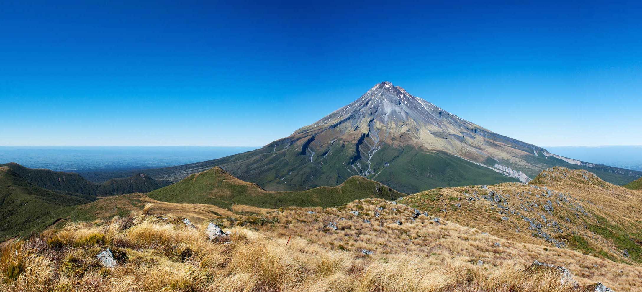
The 19-kilometre route delivers hikers from Mount Taranaki across to the Pouakai Ranges by way of climbs, forests and wetlands. The trail begins in earnest (at 950 metres above sea level) with a prolonged ascent up Mount Taranaki’s Razorback Ridge (1400 metres above sea level), before traversing the mountain and then leading steadily downwards towards the tussock-strewn wetlands.
The trail then ascends again, this time up the Pouakai Ranges through the ‘goblin forest’, past twisted trunks and sunshine-hungry saplings, with the reward of remarkable views at the top across the valley towards Mount Taranaki — reflected perfectly in the waters of the Pouakai Tarn, if the weather is favourable. Thankfully after two reasonable climbs, the trail descends gently down the Mangorei Track, through enchanting forest rich with birdsong, towards the pick-up point.
The trek is divided into five clear sections, which are outlined below.
Visitor Centre to Razorback Ridge
junction | 1.5 hours
Terrain: Continually uphill, through shaded forest.
Beginning at the Visitor Centre — the drop-off or starting point — the Razorback Ridge leads walkers high above the clouds, where they’ll remain for the first four hours of the hike. The ridge is immured by walls of verdant plants and trees, including the putaputaweta tree, and suspended tangles of old man’s beard. Trees grow shorter as the altitude increases.
At the end of a 90-minute ascent, the ridge opens out and walkers arrive at a small junction. They can choose to ascend to the summit (around eight hours return) or turn right to continue walking at the same altitude (around 1400 metres above sea level), joining a path that is sliced into the side of the mountain.
Razorback Ridge junction to Holly Hut | 2.5 hours
Terrain: Mostly flat with occasional rocky areas, which involve some light climbing.
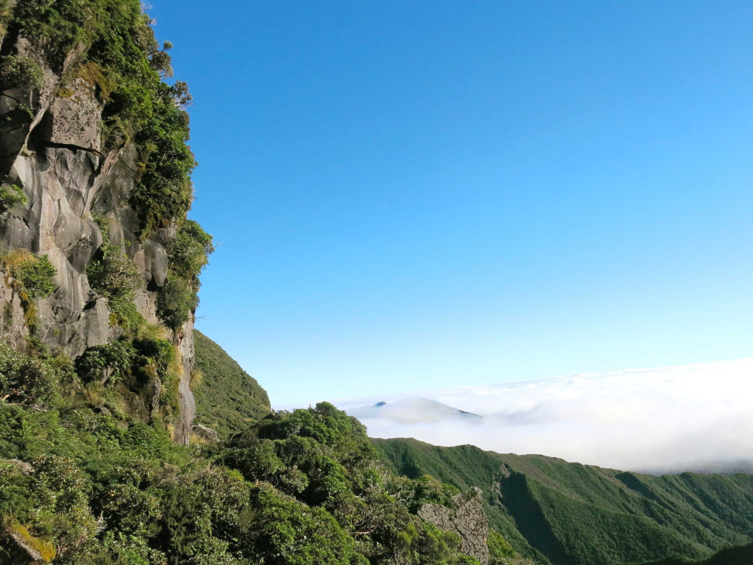
After a relatively steep ascent, the traverse towards Holly Hut is an enjoyable and easy walk with glorious views above the cloud line. On a clear day, the peaks of Mount Ruapehu (New Zealand’s largest volcano) and Mount Ngauruhoe protrude above banks of fluffy white clouds. There is a feeling of being absorbed by the mountain, almost as if one becomes the eyes of the mountain looking outwards.
The trail is a small section of a 55-kilometre track that circumnavigates Mount Taranaki, with the might of the mountain to the left and the bluff to the right. The path is a little narrow in places and the traverse across Boomerang Slip, with its steep face and loose stones, requires hikers’ full attention. This is the most exposed part of the walk and the most dangerous in case of a sudden change in weather conditions.
Arriving at Holly Hut, one is met with a basic lodge sleeping up to 26 people, with space in front for a couple of tents. It offers clean water and a basic, single outdoor toilet.
Holly Hut to Ahukawakawa Wetlands | 1 hour
Terrain: Initially downhill before arriving at the flat wetlands area, which is muddy and wet.
The most diverse section of the walk, the Ahukawakawa Track begins at Holly Hut then gently descends Mount Taranaki, leading hikers down into the clouds that were viewed previously from above. The smooth peak of The Dome can be seen on the left, and rainbows appear every few hundred metres as the sunlight refracts off the clouds.
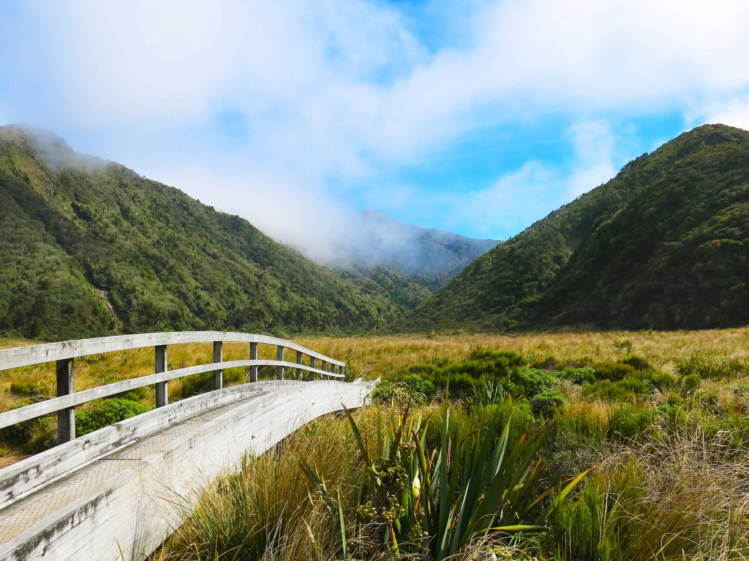
The Ahukawakawa Wetlands features a narrow boardwalk, which is flanked by pillows of sphagnum moss each side. The moss can hold up to 25 times its weight in water so stepping off the boardwalk will result in feet plunging into the soaking wet, spongy mass.
Clouds roll past the tips of the long grass, the tussock sways, and there’s not a person to be seen: this is unmistakably New Zealand. The caramel-coloured stalks, dramatic peaks and rustic wooden bridges make this a photographer’s dream.
Ahukawakawa Wetlands to Pouakai Hut | 1-1.5 hours
Terrain: A steep climb for about one hour, with flat, easy walking once at higher ground.
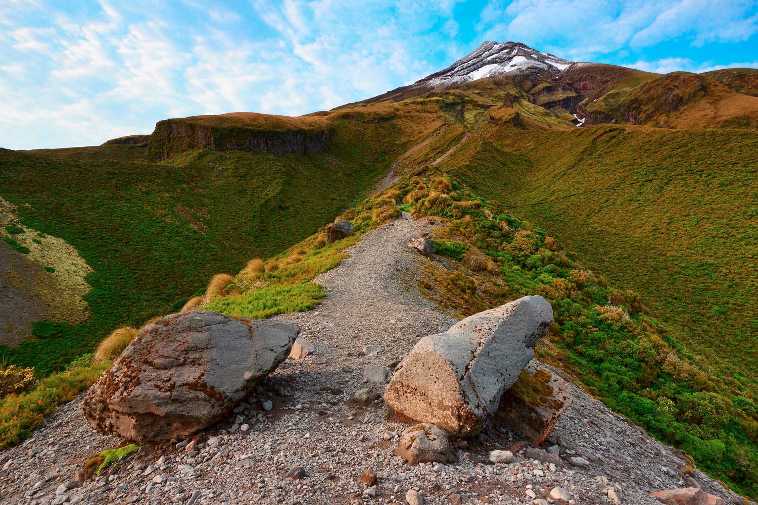
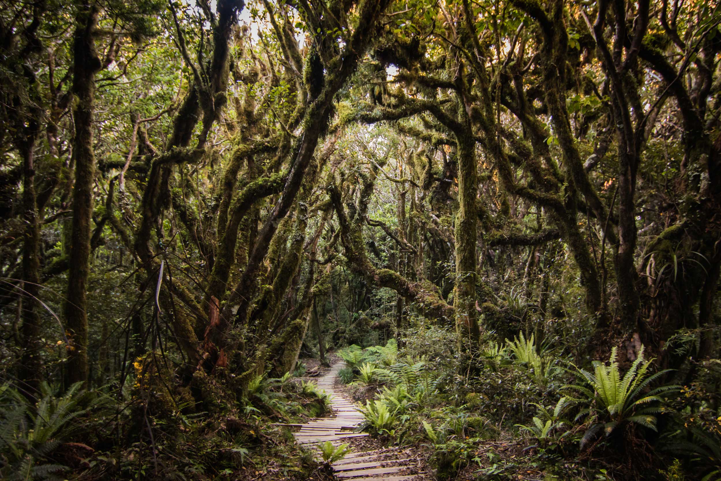
The Ahukawakawa Wetlands section of the trail lasts only perhaps 30 minutes, then the ascension of the Pouakai Ranges begins, up hundreds of widely spaced and steep steps. The steps eventually give way to ‘goblin forest’, with trees crowding each side of the track, sunlight streaming in through pockets in the leafy canopy overhead.
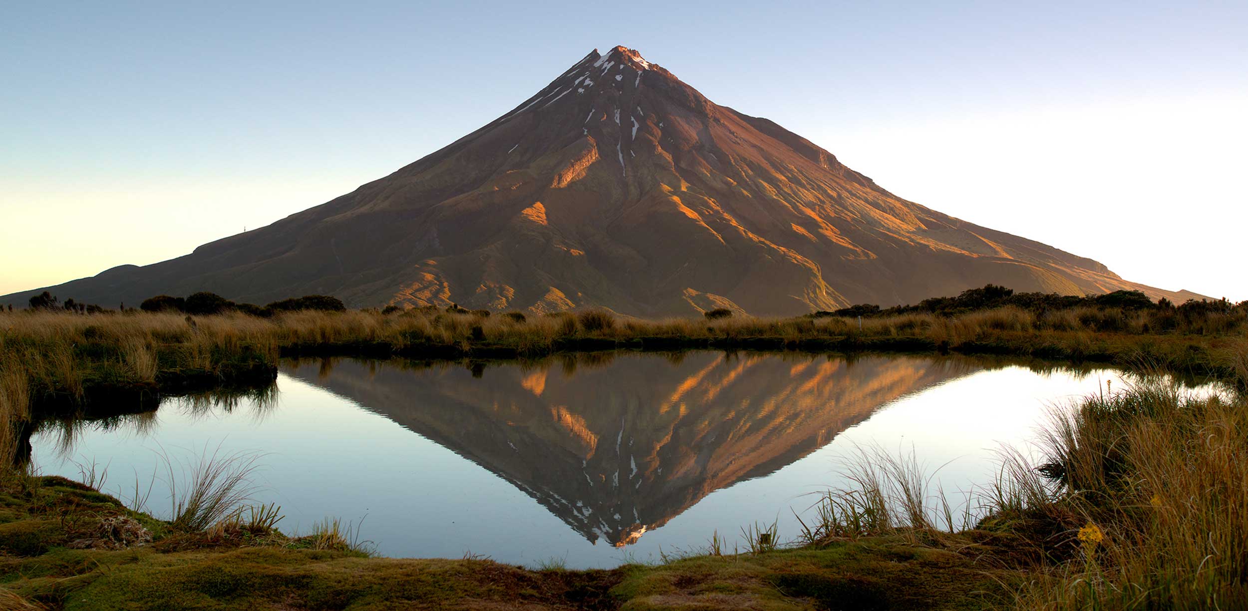
About three-quarters of the way up the Pouakai Ranges, the trail opens onto a flat area that faces Mount Taranaki; this is where the mountain’s colours of red ochre and burnt yellow truly come alive. Its beauty is best appreciated from the banks of the Pouakai Tarn, which is a 40-minute return walk from here. Seeing Mount Taranaki reflected in the tarn is a postcard-perfect scene.
From the tarn, hikers can choose to ascend to the highest peak of the Pouakai Ranges or continue on the path towards the Pouakai Hut. The hut is again basic, with bunks, a simple kitchen and single outdoor toilet. Views from the hut over the valley below are wonderful, making this an excellent overnight stop. A trip to the tarn at sunset is popular with those staying here for the night.
Pouakai Hut to pick-up point | 2–2.5 hours
Terrain: Downhill, with a firm wooden boardwalk and handrails.
Descending the Pouakai Ranges is pleasurable, following the Mangorei Track on a sturdy wooden boardwalk with a gentle incline. The mountain is behind and left, with the valley and sweeping views to the right. After about half a kilometre vegetation builds on both sides and the track descends through lush forest. Beware the sharp, serrated leaves of the bush lawyer plants that sway innocuously in the breeze with the aim of hooking into clothes and skin. Mighty totara trees begin to appear as the altitude ticks down, the path finally clearing to farmland, and the end of the trail.
Who This is For
As the trail features two significant climbs, a good level of fitness is required in order to complete the trail in a single day. Those with limited fitness can opt to stay overnight at Holly Hut or Pouakai Hut, to break the crossing into two more manageable sections.
At times the trail is quite poorly signposted and a little confusing, so walking the crossing unguided is recommended only for seasoned hikers, those who feel confident about their sense of direction and are adequately equipped. Hiking the crossing with a guide is a hugely enjoyable way to experience the walk and takes the element of risk out of the equation — highly recommended.
When to Go
While the crossing remains a well-kept secret, the best time to go is during the spring and summer months (November to April) when the steps and wetlands track will be relatively dry. As the crossing becomes more popular, summer will become very busy with tourists, making October-November or April-May a quieter time to go.
Winter hikes are suitable only for advanced hikers with appropriate snow gear, as icy conditions and poor visibility make it a very challenging route.
Where to Stay
New Plymouth is a charming city with a variety of large hotels, quaintly historic guesthouses and B&Bs, all of which can arrange shuttles to the pick-up and drop-off points. Freedom camping is permitted in front of the Visitor Centre in North Egmont at the start of the trail.
ESSENTIAL INFORMATION
- Māori believe the that mountains are the spirits of their ancestors; it is therefore considered a great privilege to walk or climb the mountain. The highest peak of the mountain is considered the ‘head’ of their ancestor, so visitors who walk the summit path are asked to respect this by refraining from climbing the very highest peak or rock at the top.
- New Zealand weather changes very quickly. Those who have been rescued on Mount Taranaki have usually been badly equipped, with poor clothing choices and knowledge about incoming weather patterns. Good, sturdy footwear is essential, as well as multiple layers of non-cotton clothing (ideally breathable merino or polyester).
- Some parts of the track are muddy, so wearing shorts is advisable. Keeping the legs cool makes it easier to regulate body temperature by switching out top layers.
- As the Pouakai Crossing takes 8-9 hours to complete, it is best to begin early — 8am is ideal — to allow for plenty of rest breaks en route.
- The Visitor Centre that marks the beginning of the trail is a 30-minute drive from New Plymouth. Shuttles are easy to arrange, and will drop hikers to the Visitor Centre in the early morning and collect them from the pick-up point around 5:30pm.
- If parking at the Visitor Centre and returning the same day, walkers should turn around at the end of the Ahukawakawa Wetlands boardwalk, which is around the four-hour point.
USEFUL LINKS
www.doc.govt.nz/pouakaicrossing