Maine, USA · Port of call
A Snapshot of Bar Harbor, Maine, and Acadia National Park
Bar Harbor is the town most visitors see first on Mount Desert Island, and often the only one. A single day ashore is enough for its shoreline, its tidal sandbar and the best-known stops in Acadia National Park.
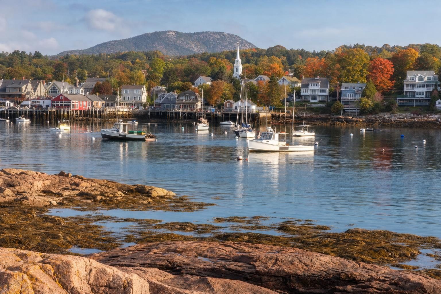
The first tender of the morning leaves the ship at about the time the fishing boats are already out, and the wind across Frenchman Bay in autumn has a bite to it that the sun has not yet softened. From the water, Bar Harbor appears in layers: a low line of granite and seaweed, a strip of lawns and shingled houses, church spires, and behind it all the rounded, wooded hills of Mount Desert Island turning red and gold.
Bar Harbor sits on the island’s north-east shore and is the busiest town on it. Most visitors come for Acadia National Park, which covers much of Mount Desert Island, and for the town’s own mix of harbour, Gilded Age architecture and seafood. Those arriving by cruise ship usually get only part of a day. That is not enough to know the place, but it is enough for a clear snapshot if the hours are spent in the right order.
Plan your visit
- Getting around
- Free Island Explorer buses into the park in season, from the Village Green More
- Time
- The bar to Bar Island is walkable for roughly an hour and a half either side of low tide More
- Distance
- The Park Loop Road runs about 27 miles past the best-known stops More
- Tickets
- Driving to the Cadillac Mountain summit needs a park vehicle reservation in the main season More
Ashore at the town pier
The tenders land at the town pier beside Agamont Park, a small sloping lawn with benches looking out over the harbour and the Porcupine Islands. Early in the day the streets above are quiet. Main Street and Cottage Street run uphill from the water, lined with galleries, bookshops, outdoor outfitters, ice cream counters and a great many places selling lobster in one form or another. The Village Green, a short walk away, is the town’s central square and the stop for the free Island Explorer buses that run into the park in season.
Cruise traffic is a live issue here. In 2022 the town’s voters approved a cap of 1,000 cruise passengers coming ashore per day, a measure that has been argued over in court ever since. On a day with several ships at anchor, it is easy to see why: by mid-morning the pier and the streets around it fill quickly.
The early tender is worth catching.
The Bar Island sandbar
At the bottom of Bridge Street, a few minutes’ walk west of the pier, the town gets its name. Here a bar of gravel, sand and crushed shell connects Bar Harbor to Bar Island across the harbour, but only for part of each day. For roughly an hour and a half either side of low tide the bar is dry enough to walk or cycle across, and on the far side a short trail climbs through the woods of the island, which is part of Acadia National Park, to a viewpoint looking back over the town and the hills.
The tide here rises and falls by around three metres, and it comes in fast. Anyone crossing needs a tide table and a watch, because once the bar floods the only way back before the next low tide is by boat.
Walking the Shore Path
Back at the pier, the Shore Path heads south along the water. It is a public right of way, laid out in the late nineteenth century, that runs for a little under a mile between the rocky shore and the lawns of some of Bar Harbor’s grandest houses. On one side, waves wash over pink granite ledges; on the other, hedges and gates hint at the summer “cottages” of the families who made Bar Harbor famous, many of them with dozens of rooms.
In the decades after the Civil War, Mount Desert Island became a summer retreat for some of the richest families in the United States, among them Rockefellers, Vanderbilts, Pulitzers and Astors. Bar Harbor, then still officially part of a town called Eden, was the centre of that summer society. The town was renamed Bar Harbor in 1918.
Much of that world went up in smoke in October 1947, when a wildfire that had started west of the town burned across a large part of the island, through the national park and into Bar Harbor itself. Dozens of the great summer estates were destroyed in a few hours. Many were never replaced, and the forest that grew back on the burned slopes is one reason the hills around the town turn so bright in autumn: birch and aspen, which colonise burned ground, change colour far earlier and more vividly than the spruce they replaced.
Into Acadia National Park
Acadia was the first national park east of the Mississippi. Its land was gathered piece by piece through donations by summer residents, led by George B. Dorr, a Boston-born conservationist who gave much of his life and money to the cause. The area was protected as Sieur de Monts National Monument in 1916, became Lafayette National Park in 1919 and took the name Acadia in 1929. Dorr was its first superintendent.
Shore excursions usually follow the Park Loop Road, a scenic route of about 27 miles that strings together the park’s best-known stops. Ships’ tours tend to allow twenty minutes or so at each, enough for a look and a short walk. Independent visitors with the same time can take the Island Explorer buses or join a local tour from the Village Green.
- 01
Sieur de Monts and the Wild Gardens
Spring house · original Abbe Museum building · native plant gardens
The first stop is often Sieur de Monts, a wooded hollow with a spring, a small stone spring house and the original trailside building of the Abbe Museum, which tells the story of the Wabanaki, the Native peoples of Maine; its main museum is in downtown Bar Harbor. Next door, the Wild Gardens of Acadia display hundreds of the island’s native plants in small habitat plots, labelled by volunteers. The Jesup Path, a boardwalk through birch woods and wet meadow, starts here and is lovely in October.
- 02
Sand Beach, Thunder Hole and Otter Cliff
Shell sand · Thunder Hole best around two hours before high tide
The road then runs down the eastern shore. Sand Beach is a rare stretch of sandy shore on a coast of rock, made largely of crushed shell. A little further, Thunder Hole is a slot in the granite where incoming waves trap air in a small cave and force it out with a deep boom. It performs best around two hours before high tide on a day with a decent swell; at low water in calm weather it can be disappointingly quiet. Beyond it, Otter Cliff rises sheer from the sea, one of the highest headlands on the Atlantic coast of the United States.
- 03
Jordan Pond and the Bubbles
Glacial lake · loop trail of just over three miles · popovers
Inland, Jordan Pond is a long, clear glacial lake with two rounded hills, North and South Bubble, at its far end. A trail of a little over three miles circles the water. Jordan Pond House, on the southern shore, has served afternoon tea with popovers on its lawn for more than a century; the popovers are large, hollow and served with butter and strawberry jam, and on a fine afternoon the wait for a table can be long.
Running through these woods are the carriage roads, around 45 miles of broken-stone roads financed by John D. Rockefeller Jr. between about 1913 and 1940 for horse-drawn carriages. They cross seventeen stone-faced bridges, each designed individually, and remain closed to motor vehicles.
Cadillac Mountain at the top of the day
The last climb of the loop is up Cadillac Mountain, at around 1,530 feet the highest point on Mount Desert Island and on the whole Atlantic seaboard of the United States. A winding road reaches the bald granite summit, where stunted pitch pine and blueberry cling to cracks in the rock. In the main season, driving to the top requires a vehicle reservation from the park.
The view takes in almost everything the day has passed: Bar Harbor and the Porcupine Islands below, Frenchman Bay, the Schoodic Peninsula across the water and the ragged coast running away to the south-west. On clear autumn days, the colour on the slopes below looks almost artificial. Raptors ride the updrafts along the ridge during the autumn migration.
Cadillac Mountain is also famous for sunrise. For part of the year, roughly from autumn into early spring, its summit is among the first places in the United States to catch the morning sun, and in summer hundreds of people drive up in the dark to watch it rise over the bay. Walkers can reach the top on foot instead: the North Ridge and South Ridge trails both climb over open granite, the southern route being the longer of the two at several miles each way. Neither fits into a cruise day, which is one more reason most people who see Acadia National Park from a tour bus promise themselves a return trip.
Back to Bar Harbor before the tide
By mid-afternoon the ships begin calling their passengers back. There is usually time for one more stop in town: a lobster roll, a bowl of chowder or a slice of blueberry pie, since Maine is one of the world’s main producers of wild blueberries. On the walk to the pier, the bar at the bottom of Bridge Street tells the time better than any clock. In the morning it was a road; by late afternoon it is under water.
For readers planning other short port visits, the guide to 48 hours in Klaipėda covers another harbour town best seen on foot. Lovers of fjords and granite may also enjoy the magnetism of Fiordland, and those continuing across the United States by road will find the long view in the story of Route 66.
If you have only a few hours in Bar Harbor, check the tide table before anything else. It decides whether the walk to Bar Island is possible, and when Thunder Hole is worth the stop.
Questions before you go
Where is Bar Harbor?
Bar Harbor is a town on the north-east shore of Mount Desert Island on the coast of Maine, in the north-east United States. It is the main gateway to Acadia National Park, which covers much of the island.
Can you walk to Bar Island from Bar Harbor?
Yes, but only around low tide. A gravel bar off Bridge Street is exposed for roughly an hour and a half either side of low tide; the park advises checking tide tables and returning in good time, because the bar floods quickly and the walk back is cut off until the next low tide.
What is the Shore Path in Bar Harbor?
The Shore Path is a public footpath that starts near the town pier and follows the waterfront south for under a mile, passing between the rocky shore and the lawns of historic summer cottages. It is free, mostly level and open all year.
How high is Cadillac Mountain?
Cadillac Mountain rises to about 466 metres (1,530 feet), the highest point on Mount Desert Island and on the US Atlantic seaboard. A paved road leads to the summit; in the main season a vehicle reservation is required to drive it.
What is Thunder Hole?
Thunder Hole is a narrow inlet in the granite shore of Acadia National Park, beside the Park Loop Road. When waves roll in, especially around two hours before high tide in rough weather, air trapped in a small cave is forced out with a deep boom and spray can shoot well above the rocks.
What are the Acadia carriage roads?
They are broken-stone roads built for horse-drawn carriages, financed by John D. Rockefeller Jr. between roughly 1913 and 1940. About 45 miles of them lie within the park, crossing seventeen stone-faced bridges, and they are closed to cars but open to walkers, cyclists and horses.
What is Jordan Pond House known for?
Jordan Pond House is a restaurant inside Acadia National Park that has served tea and popovers on its lawn for more than a century. The lawn looks across Jordan Pond to the rounded hills known as the Bubbles.
When did Acadia become a national park?
The land was first protected as Sieur de Monts National Monument in 1916, became Lafayette National Park in 1919 and was renamed Acadia National Park in 1929. George B. Dorr, who led the land-gathering effort, was its first superintendent.
Does Bar Harbor limit cruise ship passengers?
In 2022 Bar Harbor voters approved a cap of 1,000 cruise passengers coming ashore per day. The rule has since been challenged in court, so visitors arriving by ship should check the current arrangements with their cruise line.
What is the Abbe Museum?
The Abbe Museum is a museum of the Wabanaki, the Native peoples of Maine. Its main building is in downtown Bar Harbor, and its original small trailside museum stands at Sieur de Monts in the national park, open seasonally.